Import OSM data into PostGIS
In this tutorial, we'll learn how to use Baremaps to import contour lines data in a PostGIS database.
Notice that the following steps assume that the Apache Baremaps CLI and PostGIS are installed.
Also, if you are in a hurry, consider skipping the "Under the Hood" sections.
Dataset
OpenStreetMap (OSM) is a free and editable map of the world. It is maintained by a community of passionate volunteers in a way which is similar to Wikipedia. Every week, OpenStreetMap publishes a full dump (opens in a new tab) of its data in two flavours: a large XML file of about 90GB and a more compact binary file of about 50GB in the Protocol Buffer Format (opens in a new tab) (PBF). As processing such large files can take several hours, Geofabrik (opens in a new tab) regularly publishes smaller extracts of OSM for specific regions. In this example we will use a tiny extract of OSM for Liechtenstein (opens in a new tab), which is suitable for fast experiments.
Importing OpenStreetMap Data
A workflow is a directed acyclic graph of steps executed by Baremaps. To download and import the sample OSM data in Postgres, execute the following workflow (opens in a new tab).
cd examples/openstreetmap
baremaps workflow execute --file workflow.json
Depending on the size of the OpenStreetMap file, the execution of this command may take some time. Eventually, the output produced by the command should look as follows.
[INFO ] 2022-07-26 09:47:40.906 [main] Workflow - Executing workflow workflow.json
[INFO ] 2022-07-26 09:47:41.208 [pool-2-thread-1] DownloadUrl - Downloading https://download.geofabrik.de/europe/liechtenstein-latest.osm.pbf to liechtenstein-latest.osm.pbf
[INFO ] 2022-07-26 09:48:14.496 [pool-2-thread-1] DownloadUrl - Finished downloading https://download.geofabrik.de/europe/liechtenstein-latest.osm.pbf to liechtenstein-latest.osm.pbf
[INFO ] 2022-07-26 09:48:14.497 [pool-2-thread-2] ImportOpenStreetMap - Importing liechtenstein-latest.osm.pbf into jdbc:postgresql://localhost:5432/baremaps?&user=baremaps&password=baremaps
[INFO ] 2022-07-26 09:48:14.504 [pool-2-thread-2] HikariDataSource - HikariPool-1 - Starting...
[INFO ] 2022-07-26 09:48:14.669 [pool-2-thread-2] HikariPool - HikariPool-1 - Added connection org.postgresql.jdbc.PgConnection@13d835e3
[INFO ] 2022-07-26 09:48:14.671 [pool-2-thread-2] HikariDataSource - HikariPool-1 - Start completed.
[INFO ] 2022-07-26 09:48:19.172 [pool-2-thread-2] ImportOpenStreetMap - Finished importing liechtenstein-latest.osm.pbf into jdbc:postgresql://localhost:5432/baremaps?&user=baremaps&password=baremaps
[INFO ] 2022-07-26 09:48:19.172 [pool-2-thread-2] HikariDataSource - HikariPool-1 - Shutdown initiated...
[INFO ] 2022-07-26 09:48:19.177 [pool-2-thread-2] HikariDataSource - HikariPool-1 - Shutdown completed.
[INFO ] 2022-07-26 09:48:19.178 [pool-2-thread-3] ExecuteSqlFile - Executing indexes.sql into jdbc:postgresql://localhost:5432/baremaps?&user=baremaps&password=baremaps
[INFO ] 2022-07-26 09:48:19.179 [pool-2-thread-3] HikariDataSource - HikariPool-2 - Starting...
[INFO ] 2022-07-26 09:48:19.213 [pool-2-thread-3] HikariPool - HikariPool-2 - Added connection org.postgresql.jdbc.PgConnection@25c4ab89
[INFO ] 2022-07-26 09:48:19.213 [pool-2-thread-3] HikariDataSource - HikariPool-2 - Start completed.
[INFO ] 2022-07-26 09:48:21.365 [pool-2-thread-3] ExecuteSqlFile - Finished executing indexes.sql into jdbc:postgresql://localhost:5432/baremaps?&user=baremaps&password=baremaps
[INFO ] 2022-07-26 09:48:21.365 [pool-2-thread-3] HikariDataSource - HikariPool-2 - Shutdown initiated...
[INFO ] 2022-07-26 09:48:21.367 [pool-2-thread-3] HikariDataSource - HikariPool-2 - Shutdown completed.
[INFO ] 2022-07-26 09:48:21.368 [main] Workflow - Finished executing workflow workflow.json
Under the Hood (Optional)
What can we learn from this output? First, we notice that Baremaps uses a connection pool to parallelize the import procedure. Then it imports the OSM data, populating the tables previously created. In our case, the input is a file provided by Geofabrik.
OSM's conceptual model (opens in a new tab) builds upon the notions of nodes, ways and relations. In this normalized data model, a line (or way) is formed by a sequence of points (nodes) referenced by their id. In order to save denormalized geometries in PostGIS (e.g. linestring, polygon, multi-polygon, etc.), Baremaps creates a cache for nodes, ways and relations. LMDB (opens in a new tab) is used under the hood to achieve great performance.
After the creation of the cache, Baremaps can populate the database with geometries.
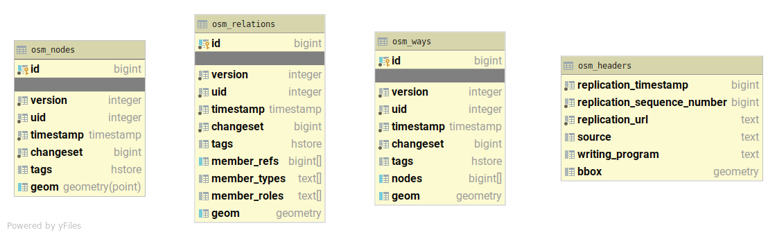
The geometries are stored in three tables named after the OSM conceptual model: osm_nodes, osm_ways, and osm_relations.
In order to improve performances at query time, Baremaps also creates indexes for the tags and the geometries.
The following Figure displays the schema of the PostGIS database created by Baremaps.
Conclusion
In this tutorial, we learnt how to import OpenStreetMap data in PostGIS.
Now that you have inserted the OSM data into the PostGIS database, you can use follow the Serve Vector Tiles from PostGIS example to serve your PostGIS data directly as Vector Tiles in a web application with live reload capabilities.